
Description
This is an 18 x 24″ print version of the Door County map (available as a digital download) on high quality paper portrait orientation.
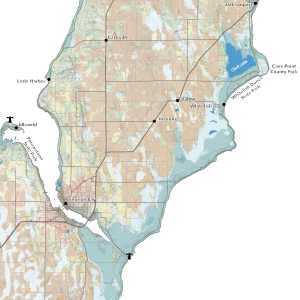
This map stretches from the southern end of Door County up through the northernmost point at Rock Island State Park. For the base layer, it uses a combination of land use classification and shaded relief. This gives the land some texture as well as imparting information about where the county’s farms, wetlands, and many protected outdoor spaces are. Inhabited places are labeled along with the larger of the peninsula’s islands. In the lower righthand corner, some information about the area is included with the scalebars and declination diagram.
All printed maps are printed on demand. Please factor 3-5 business days before your order ships.
The map was produced on QGIS with open imagery and data from the USGS and OpenStreetMap.
Reviews
There are no reviews yet.